
(From Google Street View)
The year 2007, when Google first began driving those ridiculous camera-topped cars around U.S. cities, doesn’t feel so long ago. But seven years is a lifetime on the streets of a rapidly changing city like Washington.
So much in the District has changed so quickly that it’s almost hard to remember what once-empty or neglected corners of town looked like before they were redeveloped. Google, however, has just made it possible to travel back in history — very recent history, that is. For the first time, Google has uploaded all of the archival imagery captured over the years by its Street View cars into its map interface.
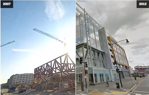
Travel now in Street View to the corner of First and M streets NE, and we can see the neighborhood as it appeared there every time a Google car passed by over the last seven years: first in November of 2007, then June of 2008, July of 2009, August and September 2011, and then May of 2012.
In a lot of cities, on a lot of corners, that brief timespan reveals only modest change — maybe a new paint job or an added bike rack. In the NoMa neighborhood, though, the transformation is stunning:
As historic archives go, this one is admittedly shallow. But throughout Washington in particular — and in comparably evolving parts of New York City, San Francisco, or Seattle — Google’s new timelapse tool reveals the dramatic change that has come with the arrival of new residents and resources in just the last few years alone, sometimes at the expense of existing residents.
In less than a decade, the 14th Street Northwest corridor in the District has transformed into an entertainment hub lined with bars and boutiques. Entire glass office towers have appeared out of the dust near the Navy Yard. The NoMa area today contains millions of square feet of retail, hotel rooms, office space and residences that did not exist only a few years ago.
Google, of course, makes no commentary on  whether we should call these events gentrification or revitalization. But for anyone having that conversation, these images will be deeply relevant.
These archives exist in nearly every neighborhood, in every city visited by the Google fleet thus far, including outside the United States. So you can walk down your own block, too. Just click on the small clock icon (“NEW!”) in the upper left-hand corner of the Street View window in Google Maps, and a timelapse will appear.
In Washington, we’ve pulled out several particularly striking scenes that reveal the scale and variety of change here, as old rowhouses have been refurbished, or as entirely new buildings have popped up. If readers want to share links to Street View scenes in other cities in the comments section below, we’ll compile those, too.
Here is the Howard Theater off T Street and Florida Avenue in Northwest:
The offices of the D.C. Department of Transportation, atop the Navy Yard Metro entrance near Nationals Park in Southeast:
New development at 14th Street and Florida Avenue NW, on both sides of the street:
Within residential neighborhoods, some of the change is more modest, as boarded-up rowhouses have been remodeled, such as in the Bloomingdale neighborhood…
That residential change has brought with it new retail and restaurants, as with Shaw’s Tavern at Sixth Street and Florida Avenue NW…
… and even new forms of transportation, as with the street car tracks seen here on H Street, another emerging corridor where once-boarded store fronts are slowly taking new shape:
You may recognize, as on H Street, that much has changed even since the last time Google passed through the city. In many neighborhoods, the cars haven’t been by since 2011 or 2012. But now that Google is building both a walking tour of every city and a historic archive of cities across time, we clearly need another update in the District.
(Big thanks go to The Washington Post’s Jonathan O’Connell, Laris Karklis and Darla Cameron for compiling and creating these slides.)